
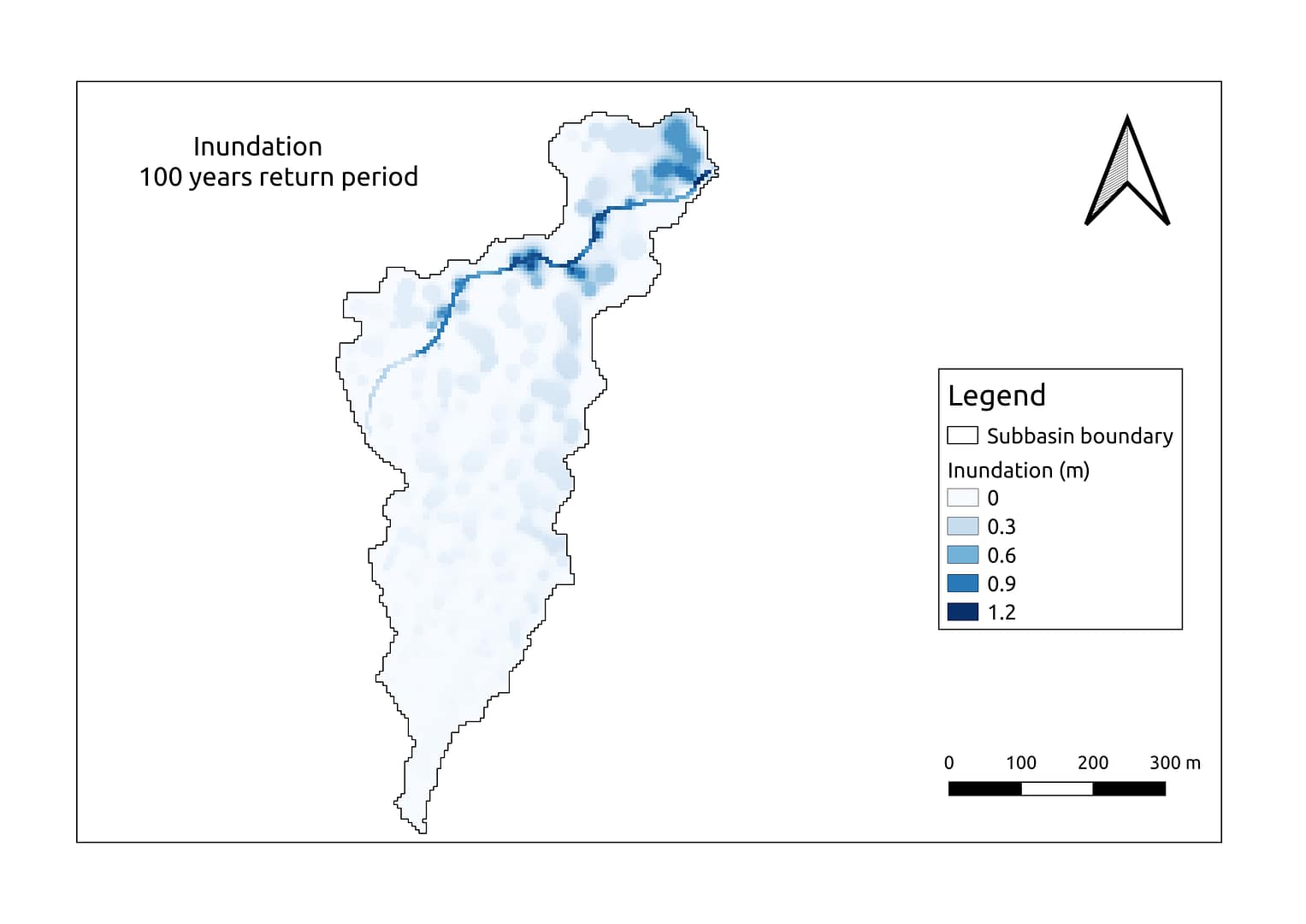
The catastrophic impact the flood caused to both life and property is known to all . So, any industry before the establishment of any project wanted to rule out all the possibility of the risk caused by the flood. Satyukt Analytics, an expert in microwave remote sensing was contracted for computing: Design storm scenarios...

Relative crop yield is estimated by using the methodology defined by FAO. Relative crop yield is a measure of yield with respect to the best yield for the same variety. Here at Satyukt, by using multi-satellite data we estimate the relative crop yield. The above map shows the same estimation for Mandsaur district of...

India is experiencing an increase in widespread drought in recent decades due to climate change. This not only affects crop productivity, but also exacerbates groundwater extraction that cause conflicts among people, increasing migration and economic stress. A satellite based Vegetation Condition Index (VCI) is being used for the estimation of crop health as well...

The conventional method of crop mapping includes field survey and statistics sampling. While using the conventional methods, it requires a lot of resources and it is almost impossible to do at regional and global levels. The remote sensing techniques can be used to map the crop, at farm to regional scale at greater efficiency....

Cat-crop is a web portal for visualizing crop-related data. For the below variables Visualize Similarity Rank and Comparison. With 4 products in each category, Crop Yield, NDVI, Rainfall & Soil Moisture. Visualize: Display the data for a specific product.In visualizing crop yield there are 16 crops, in each of the seasons. And the data...
India, is the largest extractor of groundwater in the world1. A majority of over 60% of irrigated agriculture and 85% of drinking water supplies are dependent on groundwater. Sustainable groundwater resources is quite challenging as their is trade off in increasing the crop yield and decreasing the dependency on the groundwater resources with...
Before the setup of any project, flood analysis should be done on the selected site to rule out all the possibilities of risk from the flood. Manual survey and analysis would be tedious time taking and expensive and hence won’t be an efficient solution. Satyukt Analytics, an expert in microwave remote sensing was contracted...

Food production and water use are inextricably linked. Water has always been the main factor limiting crop production in much of the world where rainfall is insufficient to meet crop demand. The steadily rising demand for agricultural commodities, calls to improve the efficiency and productivity of water use for crop production. To examine the...

Sri Lanka is experiencing an increase in widespread drought in recent decades due to climate change. This not only affects crop productivity but also exacerbates groundwater extraction that cause conflicts among people, increasing migration and economic stress. A satellite based Vegetation Condition Index (VCI) is being used for the estimation of crop health as...

Evapotranspiration (ET) is one of the ways in which land and atmosphere interact with each other. It is the collective process of evaporation from the soil and transpiration from plants. Estimating evapotranspiration loss and crop-water requirement can be beneficial in identifying the loss and can hence help in reducing irrigation loss. With the recent...