
How Satyukt’s technologies can help Farmers.
Satyukt provides SaaS to enable data-driven farming to farmers, globally.
We process satellite images and estimate: soil moisture, vegetation indices, evapotranspiration, crop health, yield, crop water usage, and so on. With these at fingertips, farmers can put favorable management techniques in place to minimize the inputs, maximize the outputs, and eliminate waste.
Crop Health Monitoring
Using Satellite estimated vegetation indices (e.g. NDVI, EVI…, etc) that provide information about health and growth of crops. This data enables farmers to see stressed crops in a field up to two weeks before the human eye could detect.
The Benefits of Crop Health Monitoring:
- It helps to detect non-performing areas
- Assess the crop health variability within a farm
- It is used to quantify vegetation conditions within a farm
- It allows farmers to evaluate plant germination and productivity
Crop Soil Moisture
At Satyukt, we provide advanced satellite-based soil moisture estimation solutions to farmers so that they can optimize their water usage, increase produce yield, produce high-quality crops, reduce water resource degradation, and save a lot of money.
The Benefits of soil moisture data:
- Optimize water usage
- Identify correctly water-stressed plants/areas
- Reduces the degradation of water resources like groundwater
- Monitor agricultural drought in near real-time
- Useful for identifying the areas having problem areas (water stress) within the farm
- The analysis helps to identify the presence of good moisture and helps to plan when and what to sow.
- Monitoring soil moisture improves 20% of crop productivity
Irrigation Advisory
We have developed cutting edge technology that combines potential evapotranspiration, satellite retrieved soil moisture data, weather forecast data, and rainfall data to provide the real-time irrigation advisory at a farm level and insight into how much water crops need to grow without water stress.
The Benefits of Irrigation Advisory:
- Provide insights to optimize water usage
- Reduces waterlogging
- Reduces over usage of water resources
- Detection of effective water management practices
- Detect faulty irrigation system
- Help to estimate the water demands of the crop
- Help to determine whether to irrigate or not
- Assessing drought conditions
- Time series analysis helps to take decisions when to irrigate and can reduce irrigation costs.
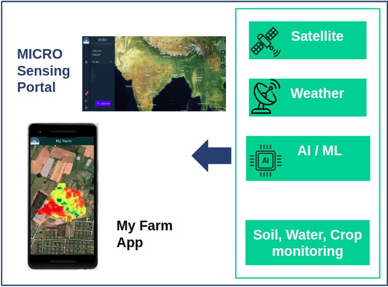
With farmers as the end-user in mind, we have developed two unique platforms,
- Micro web portal and
- MyFarmApp
Micro Web Portal
We have developed an interactive web portal in which the farmer can select his/her field by drawing a polygon on the map, in order to get accurate and understandable insights for accurate farm input management. The interface helps in visualizing, accessing, and analyzing satellite estimated agro-hydrological variables in near real-time. Farmers can customize spatial, temporal, and spectral resolutions of the variables.
MyFarmApp
We also have developed a mobile application to provide accurate and understandable insights for accurate farm input management to agriculture stakeholders for remote locations anywhere on the earth. In this application, the farmer can walk around his/her farm boundaries in order to add a farm. The added farm details are then passed on to our API. Later in our servers, we apply innovative algorithms that leverage advances in Satellite Remote Sensing technology and apply Big Data Analytics, Machine Language, and Physical Algorithms to provide the farm-scale insights. Finally, in the application, a farmer can visualize, access, and analyze satellite estimated agro-hydrological variables in near real-time.
