
Sat2Credit: Insight into farm income and risk by satellite remote sensing for BFSI
Introduction
Agriculture from time immemorial has always been a gamble with nature and its adversities. Looking back over a decade of severe weather anomalies like flood, drought, superstorms, and pest/disease infestations with impacts on a scale previously unimaginable, there is a pressing need to understand the toll that has been taken. In 2019 alone, disaster-related economic loss – from droughts in East Africa to typhoons in Mozambique to the Amazonian wildfires – amounted to USD 122 billion globally (EM-DAT CRED, 2020). Because climate change makes weather patterns more extreme, the outlook for the decade to come is a daunting one. As the need to prevent, mitigate and compensate loss grows, critical questions remain about the scale of agricultural loss and the brunt the sector bears. Heavily reliant on weather, climate and water for its ability to prosper, agriculture is particularly vulnerable to disasters, weather extremes and climate change.
Challenges in Agriculture
Staple food production in many agriculture-based countries remains largely rain-fed and uninsured against the large fluctuations caused by weather and climatic variability. Over the last decade alone, the drought and floods have taken a serious toll on agricultural production systems in almost all parts of the world and worsening the case further for agrarian countries of Africa and Asia-Pacific region.
Drought has previously been and still pose to be as the single greatest culprit of agricultural production loss. Over 34 percent of crop and livestock production loss is traced to the occurrence of drought, costing the sector USD 37 billion overall. Moreover, drought impacts agriculture almost exclusively; it sustains 82 percent of all drought impact, compared to 18 percent in all other sectors. Floods are the second gravest disaster for the agriculture sector, responsible for a total of USD 21 billion of the crop and livestock production loss in the last decade according to FAO; this amounts to 19 percent of total loss.
Credit, insurance and risk management
Acknowledging the fact that production all around the world is hampered by extreme weather calamities, the person behind the plough has to be assured with insurance that he will be compensated for such loss in crops and timely credit to revitalize his business or go on to adopt effective crop risk management strategies.
The knowledge of the scale of global losses caused due to the climate crisis in the past decade alone would be sufficient to acknowledge the fact that timely credit availability and crop insurance are the two strong pillars for effective strategy to avoid production losses especially concerned with crops. The credit facilities available at present in the agriculture sector especially in countries like India are either too time taking from the institutional sector or too costly from the non institutional sources. This ultimately puts the crops owners in a situation that is non productive.
Disadvantages of traditional method of risk assessment
The institutional credit in agriculture without the proper metrics to measure the risks and benefits will prove to be a double edged sword. Traditionally, the losses are assessed by field visit. However, this method is cumbersome, time consuming, prone to errors and difficult to scale. UAV can be used to estimate the losses, however these also require physical visits and past time is not available and thus the critical times at which credit should be made available in the production process is lost. Thus, in order to fasten the risk assessment from the institutional point of view and ensure a quicker approval process, Sat2Credit with Satellite remote sensing offers a solution which is scalable and provides information across the globe which is transparent and available at all times for all the stakeholders.
What is Remote Sensing?
Remote sensing is the acquisition of information from a distance. Various space agencies (e.g. NASA, ISRO) observe Earth and other planetary bodies using sensors aboard satellites that detect and record reflected or emitted energy. Remote sensors, which provide a global perspective and a wealth of data about Earth systems, enable data-informed decision making based on the current and future state of our planet.
Sat2Credit app
Sat2Credit application essentially provides services and metrics that will help banks simplify their process of loan approval for farmers.
The platform provides the following information over a farm:
1. Risk estimation by analyzing the historical satellite and weather data. Risk is provided at different return period along with the annual average loss (AAL) for the following perils:
- Drought
- Flood
Crop Time Series of Soil Moisture present over the farm for 5 years. It helps in assessment of water content present in soil

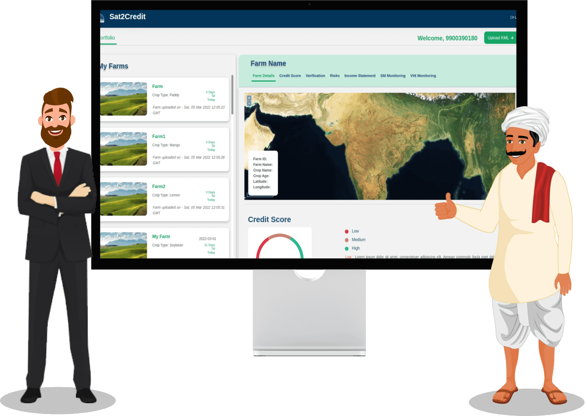
Figure 1: A screenshot of the Sat2Credit web application (www.sat2credit.com)
2. Monitoring of the portfolio for:
- Drought
- Flood
- Likely crop yield
- Pest and disease
3. Farm income computed by using the predicted yield, market price and cost of cultivation.

Figure 2: A screenshot of the farm income in the Sat2Credit web application (www.sat2credit.com)
4. Credit score estimated by combining all the estimated information.

Figure 3: A screenshot of the overview of Credit score in the Sat2Credit web application (www.sat2credit.com)
Conclusion:
From the Sat2Farm app https://play.google.com/store/apps/details?id=com.satyukt.myfarmapp), farmers can geotag their farm and apply for the credit. After that bank or any other BFSI institutions can start monitoring the farms through our sat2credit web application.
For more information, reach out to us at sales@satyukt.com or +91 8749094434


