
Soil moisture can analyze the impact of an irrigation project
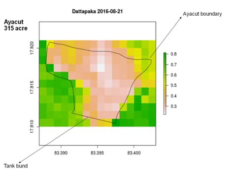
The efficiency of an irrigation project or tanks can be analyzed by using the relative soil moisture in the ayacut area before and after the completion of the project. Traditionally identification of rehabilitated tanks was done by the manual method in which an individual has to visit each of the physical sites where tanks are located. The problem arises when tanks exist in quite a large number and visiting each tank physically is almost impossible due to lack of resources. An alternate approach is to use remote sensing to map the soil moisture periodically to assess the water deficit for crops in ayacut. The figure shows a soil moisture map for Dattapakka tank, Visakhapatnam district, Andhra Pradesh. As can be seen from the figure, surprisingly the soil moisture within the ayacut (command area) is low compared to outside ayacut which shows that the irrigation project implemented is not serving its purpose.
Passive microwave sensors provide soil moisture globally at a coarser spatial resolution whereas active microwave sensors have a higher spatial but low temporal resolution (2–4 weeks). Using soil moisture data directly from any of these sensors will have compromised spatial or temporal resolution. Satyukt Analytics Pvt Ltd has developed an innovative methodology which merges active and passive microwave data to obtain soil moisture data of high spatiotemporal resolution. Some of the applications where this high-resolution soil moisture data would be useful are:
-
- Optimal irrigation in farms
- Improved flood risk estimation
- Monitor agricultural drought in near real time
- Likely crop Yield
- Irrigation Management
- Improved weather forecast
- Analyze the impact of an irrigation project
- Automatic billing of farm based on the actual irrigation


