
As water started receding in rivers :The real work of restoring normalcy begins now
First published on August 24, 2018
Displacing more than a half million people1, Kerala has been experiencing one of the worst flood in the century. The incessant rains resulted in landslides and 802 dams were opened as they reached their optimum capacity within a week, which includes Idukki dam, one of the highest arch dams in Asia. Most of the places were isolated from the mainland which made rescue operations difficult. The current flood brings back reminiscences of the flood that occurred in 1924. The flood in 1924 often termed as the “Great flood of 99″(referring to the Malayalam year 1099), which still remains as a fearful memory in the mind of many who were alive at that time has a history of subsiding even regions located about 6000 feet above the sea level. Kerala so far received 2346.6 mm against normal of 1649.5 mm (above normal by 42%)3.The rain recorded this year was 4 times that of 1924, but the causalities are comparatively less because of the efficient and scientific rescue operations.
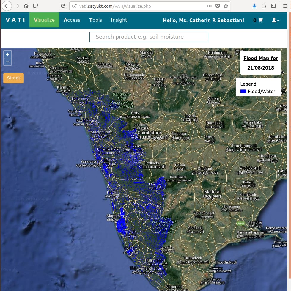
Now as the rain has been easing out and IMD has lifted red alert from all the districts, the work of restoring the state to it’s earlier stage is the goal to be achieved. According to the Union minister K J Alphons, the state desperately need technical assistance to rebuild and recreate4. Analyzing and estimating the damage occurred is the first brick in recreating or restoring the old charm of the state. In the phase of disaster relief, microwave remote sensing can play a great role in the identification of largely associated features( such as landslides), which can be successfully mapped by medium detailed imagery (SPOT, IRS etc..). Structural damages to buildings can also be analyzed in near real time using high-resolution imagery. The capability of microwave data to penetrate clouds will be an added advantage as the state has been reportedly covered by rain-clouds. The figure shows the flood map prepared from the microwave data Sentinel-1A and the data can be viewed using our application VATI
- https://twitter.com/CMOKerala?ref_src=twsrc%5Egoogle%7Ctwcamp%5Eserp%7Ctwgr%5Eauthor
- https://twitter.com/CMOKerala?ref_src=twsrc%5Egoogle%7Ctwcamp%5Eserp%7Ctwgr%5Eauthor
- https://www.imdtvm.gov.in/images/rainfall%20over%20kerala%20during%20monsoon%20season-2018%20and%20forecast%20for%20next%205%20days.pdf
- https://www.ndtv.com/kerala-news/need-this-to-rebuild-kerala-not-food-and-clothes-says-union-minister-kj-alphons-1903137


