
On the day of “Karnataka Rajyotsava” let us step in to revive the agriculture of the state
First published on November 01, 2018
After the State was formed in 1956, the agricultural sector of the state went through several changes in terms of production, productivity and cropping pattern. Spatial variation in agriculture performance is observed throughout the Karnataka, as the state is characterized by non-uniform natural endowments which differ significantly across sub-regions over time. In certain sub-regions, new crops are being introduced and the traditional crops are on the decline1. In Karnataka stagnation of productivity has become so acute that even the production in irrigated areas is also declining which may be due to the neglect of scientific water management practices and lack of proper awareness among the beneficiaries, and the technological bottlenecks 2. As water remains one of the limiting factors in the agriculture sector of the state, calculating irrigation requirement of the soil types spatiotemporally would be advantageous. Proper usage of water can increase the yield and crop health.
Precision irrigation is the practice of irrigating the crops with the optimal amount of water by monitoring agro-hydrological parameters such as soil moisture, Evapotranspiration, normalized difference vegetation index (NDVI)and Vegetation Condition Index (VCI). Monitoring these parameters is beneficial in analyzing the crop water requirement, crop health and can also help in predicting crop yield in near real-time which can tackle adverse climatic changes and reduce its effect on crop yield. Analyzing the temporal variation of these parameters can help to adapt to different agricultural practices for the betterment of yield. With the emergence of satellite sensors, Agro-hydrological variables influencing agricultural yield can be monitored with much ease.
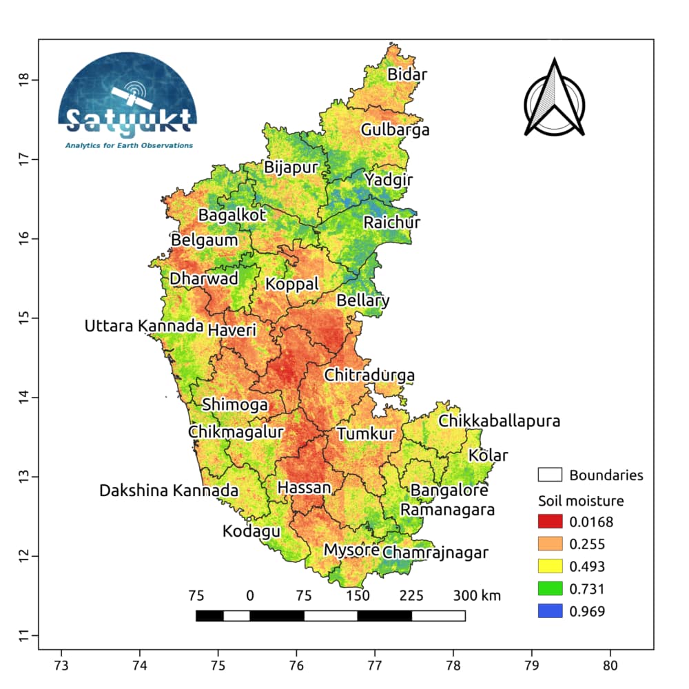
Due to demographic and market pressures, the average size of holding in the State is shrinking very fast, making a large number of farm families economically unviable almost every day. The average size of holding is 1.63 ha and the number of holdings having land less than 1.0 ha account for 42 percent of the total holdings in the State, which itself is a cause for concern. Hence High-resolution data is required to monitor. Hence high-resolution data is required to monitor the above-mentioned parameters. Currently, the satellite data available have compromised spatial or temporal resolution. In order to produce data at an optimum spatial and temporal resolution, Satyukt analytics has developed an innovative algorithm to merge multi-satellite data which can produce a resolution of 5 m. The above map shows the average soil moisture for the month of October over Karnataka. The state shows moderate soil moisture which is a good indicator for the agricultural sector of the state.
As agriculture is the backbone of any economy, On this special day let us join hands to revive the agriculture of the state.


