
Remote Sensing: The practice of evaluating and studying the physical properties of a region by detecting the reflected and emitted radiation from a distance is known as remote sensing (typically from satellite or aircraft). It aids in the acquisition of information about an object or phenomenon without making physical contact with the object or...

Introduction Agriculture from time immemorial has always been a gamble with nature and its adversities. Looking back over a decade of severe weather anomalies like flood, drought, superstorms, and pest/disease infestations with impacts on a scale previously unimaginable, there is a pressing need to understand the toll that has been taken. In 2019 alone,...
In the Indian economy, the Agriculture sector plays a primary role where nearly 70% of the rural families depend on agriculture. Agriculture is one of the major contributing sectors of the Indian economy as it contributes about 17% to the total GDP. When natural disasters such as drought, flood, earthquake, wildfires, disease, and infestation...

Floods are among the most frequent and most destructive natural hazards on earth. It causes damage worldwide of more than $40 billion annually. Heavy monsoon rains have come to India and as a result millions of people are losing their homes and more than a thousand deaths. Excessive rains in different parts of India...

In the current scenario, there are a lot of natural calamities where the importance of insurance has gained more attention than earlier and played a vital role for providing coverage against losses or damages. Challenges: It’s always a challenge to an Insurance company to fix upon a premium at an attractive rate by considering...
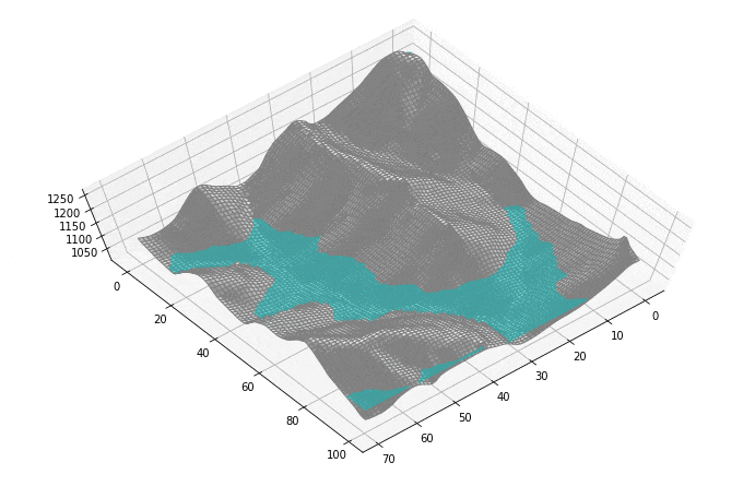
Before the setup of any project, flood analysis should be done on the selected site to rule out all the possibilities of risk from the flood. Manual survey and analysis would be tedious time taking and expensive and hence won’t be an efficient solution. Satyukt Analytics, an expert in microwave remote sensing was contracted...