
Flood Inundation Mapping of Koshi River
The Koshi river drains from the Himalayas and flows through the southern slopes of Nepal. The river crosses the northern Bihar and joins the Ganges near Kursela in Katihar district. The Koshi is 720km long and drains an area of 74,500 km2 in Tibet, Nepal, and Bihar. The Koshi river has shifted its flow for more than 133 Km from east to west during the past 250 years. The river which flowed near Purnea in the 18th century now flows west of Saharsa. A Study with satellite images shows the old channel with a confluence before 1731 with the Mahananda River north of Lava 1.
On August 18, 2008, Koshi picked up its old channel which it had abandoned over hundreds of years. Approximately 2.7 million people were affected as the river broke its embankment at Kusaha in Nepal, submerging several districts of Nepal and India. 95% of Koshi’s water flowed through the new course 2. The northern part of Bihar was worst affected. The magnitude of deaths or destruction was hard to estimate, as the affected areas were inaccessible. This incidence shows the magnitude of flood impact in Northern Bihar and how vulnerable those areas are.
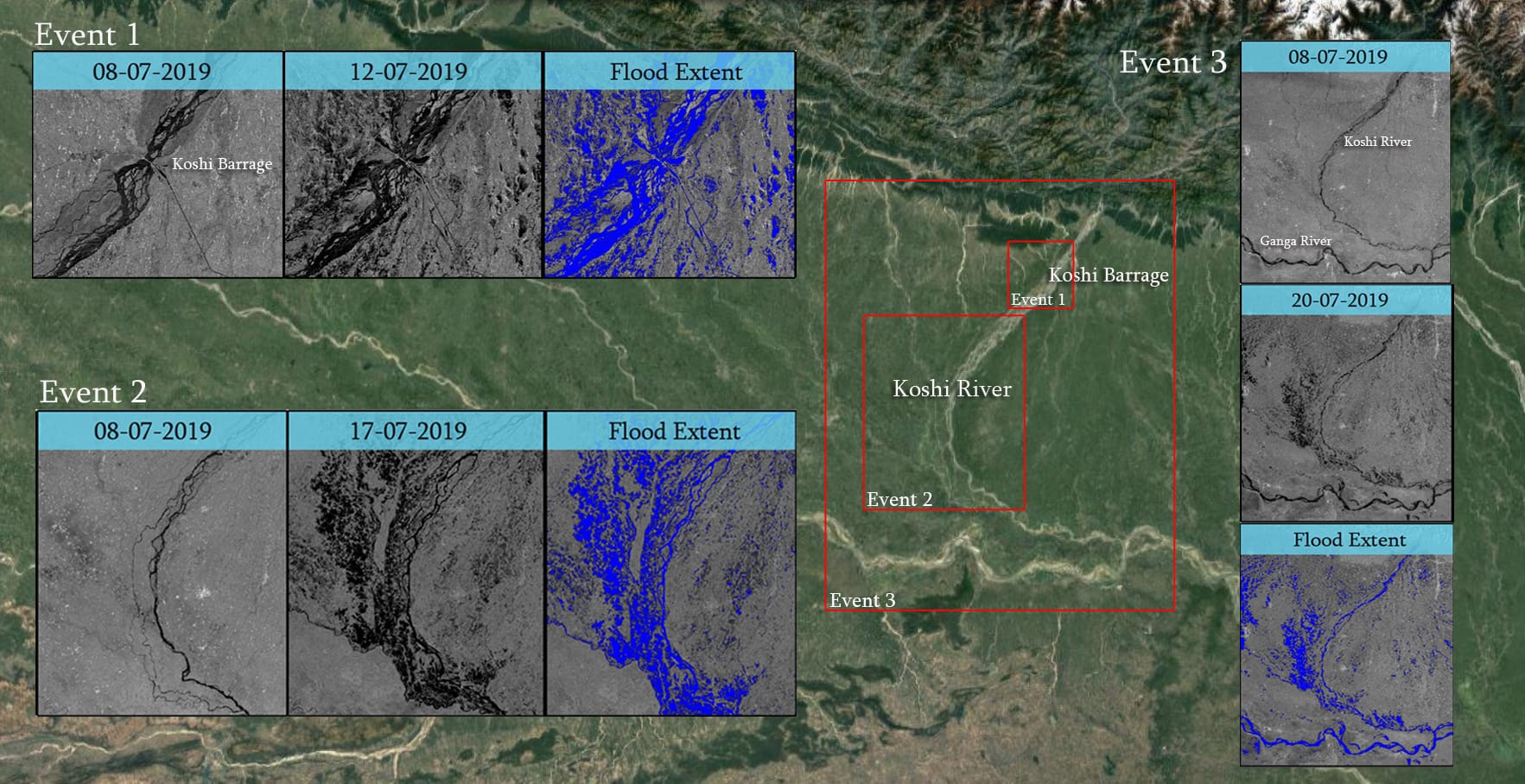
In July 2019 a similar event had taken place, Koshi flooded but this time due to the heavy rain which devastated Nepal. The trigger of the flood is due to the downpour in Nepal. On July 11 to 12th Nepal’s Simara weather station received more than 300-millimeter rainfall. The spell totaled 478.40 mm by July 13 3. On 14th July, all 56 sluice gates of the Kosi barrage were opened, releasing three lakh cusecs towards Bihar.
On 12th July 2019 around 12:13 UT European Space Agency satellite Sentinel 1 passed over the Koshi, Barrage, Nepal. The C Band Synthetic Aperture Radar has the capability to penetrate through clouds. This all-weather imaging capability helps us to estimate the extent of the flooded area. The images of 08th July and 12th July visually show the amount of water entered the Koshi Barrage and the amount of water went out.
Bihar State Disaster Management Authority stated heavy rainfall recorded in Bihar as well. On July 14, Kishanganj block alone recorded 186.8 mm rainfall within five hours followed by Kochadham block that got 164.2 mm, Thakurganj block 163 mm and Bagadurganj block 162 mm but the sudden rise of water levels in Kosi, Bagmati, Kamka Balan, Gandak, Budhi Gandak, and their tributaries was due to an extreme weather event in Nepal 4.
The high revisit of Sentinel 1 helps us to estimate the flood event on 17th July 2019. On 17th, July around 12:31 UT Sentinel 1 passes through northern Bihar. This shows the swollen nature of the river and the damage caused by the flood. BSDMA stated floods have affected more than 2.5 million people of 546 panchayats at 77 blocks in 12 districts5.
The descending pass of Sentinel 1 over North Bihar on 20th July shows the usefulness of sentinel 1 with high repeativity. As of 20th, July 92 people lost their life and 1,25,000 evacuated 6. The flood causes excessive damages to the crops. The Koshi carries 950 lakh cubic meters of sediment every year. This is also a problem for frequent flooding which earned the title Sorrow of Bihar. Satyukt has a strong team to estimate and assess such kinds of flooding. This kind of assessment can help the government to understand the immediate losses and also monitor the vulnerable areas. Satyukt is capable of assessing all kinds of flooding. This case study is a type of flash flood and flood due to heavy rain.
- R. P. AGARWAL & R. BHOJ (1992) Evolution of Kosi river fan, India: structural implications and geomorphic significance, International Journal of Remote Sensing, 13:10, 1891-1901, DOI: 10.1080/01431169208904238
- Tewary, A. (2008). “Flood devastation in Bihar state”. BBC News. Retrieved 26 August 2008
- “Bihar Is Flooding, but Where Did It Start? Hint: Look North.” n.d. Accessed April 3, 2020. https://www.downtoearth.org.in/news/natural-disasters/bihar-is-flooding-but-where-did-it-start-hint-look-north-65683.
- Tewary, A. (2008). “Flood devastation in Bihar state”. BBC News. Retrieved 26 August 2008
- “India’s Water Woes Mount, with Floods, Droughts and Millions of Citizens at the Mercy of the Monsoons – Firstpost.” n.d. Accessed April 3, 2020.
- Situation report on Flood/Heavy Rainfall in Assam, Bihar, Tripura, and Kerala as on 20th July 2019 at 1800 Hrs, National Emergency Response Center, India.


Has one comment to “Flood Inundation Mapping of Koshi River”